- Tours
- Alpinisteig
Alpinisteig
A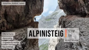
Tour-Data
Total time
04:00h
Climbing height
400 m
Total height
1000 m
Orientation
North
Alternate-Name
Strada Degli Alpini
LeadIn time
02:30h
LeadOff time
02:30h
Protection
Good
Difficultygrading variation
Variant B
Difficulties
Difficulty
A

Map
User reviews
There are no user reviews for this listing.
Already have an account? Log in now or Create an account
{{#ratings}}
{{title}}
{{#ownerCreatedBlock}}
{{/ownerCreatedBlock}}
{{#category}}
{{#editor}}
{{/editor}}
{{#user}}
{{/user}}
{{/ratings}}
-
{{#owner}}
-
{{#url}}
{{#avatarSrc}}
{{name}} {{/url}} {{^url}} {{#avatar}} {{& avatar}} {{/avatar}} {{name}} {{/url}} - {{/owner}} {{#created}}
- {{created}} {{/created}}
Category: {{category.title}}
{{/category}}
{{#fields}}
{{#showLabel}}
{{/fields}}
{{label}}:
{{/showLabel}}
{{& text}}

